
CHAPTER ONE – MAY: TRADITIONS
Thomas Lee photo
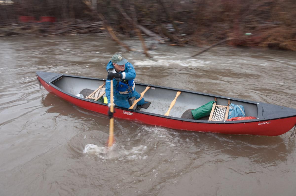
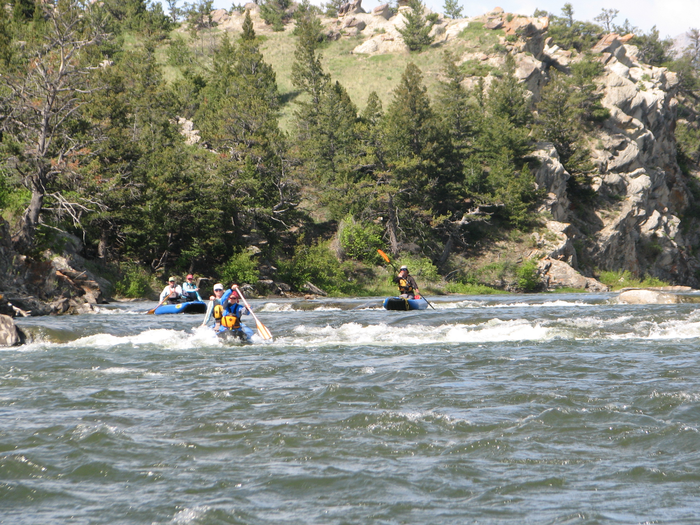
This year it is a week into May before I cajole Marypat into joining me in a canoe on the upper stretch of the East Gallatin River. I’ve checked the gauge and it’s running about 200 cubic feet per second (cfs), nothing like peak runoff, when it could barrel along with 1,000 cfs or more, but enough to get us down. I’ve run this river for some 35 years, and this uppermost bit I’ve probably been down a hundred times. I used to think nothing of taking it on solo, but as I’ve aged, and gotten less nimble, I prefer to go tandem to cope with the inevitable, repeated moments when a downed tree or beaver dam or fence suddenly appears around a bend and it’s a mad scramble to cope. The knees just don’t unbend the way they used to.
It isn’t that MP is unwilling. She’s game, but with life getting in the way as it does, we don’t always line our schedules up. We load the 16’ red boat on the rig, drive a mile north to the edge of town, and park. It isn’t a sanctioned launch and never has been. We pull off the edge of the side street, unload the boat, and lower it down the bank under a spreading willow tree with roots thicker than my thigh. I have stepped into the boat here in downpours, at bankful flood stage, on sunny spring days, at dawn and dusk, with feelings of joy and relief and anger and worry.
It was the first thing I did after I was cleared of cancer from my eye tumor, a decade ago. We got the all clear from the doctor, I went to each of the kid’s schools and got them out of class to share the news, and then I put the canoe in this water at this spot with my partner of so many years, so many shared bends of current, and for the next couple of hours full of sluicing river, hairball adventure, circling hawks, looming mountains, we celebrated.
The first time we paddled this section we had been invited by fellow paddlers who were volunteering on a river cleanup day. Why not? Although we’d lived in Bozeman a few years, knew the small river as a local feature, running right through town, we’d never considered paddling it. That day in the early 1980s there were six or eight of us in canoes and we put into the flow at precisely the same spot. Back then the local animal shelter was across the street, a nondescript industrial district sat across the way, and a dilapidated trailer park bumped up against the stream bank. Nobody noticed our launch. A mournful howl drifted across from the animal shelter.
In the decades since, some things have changed. The shelter has moved to another location. The business park has been built up. The trailer park is the same, but there are trails, foot bridges, a nearby public park, groomed ski trails during the winter. Back then it was the nondescript, somewhat decrepit municipal border that no one much noticed.
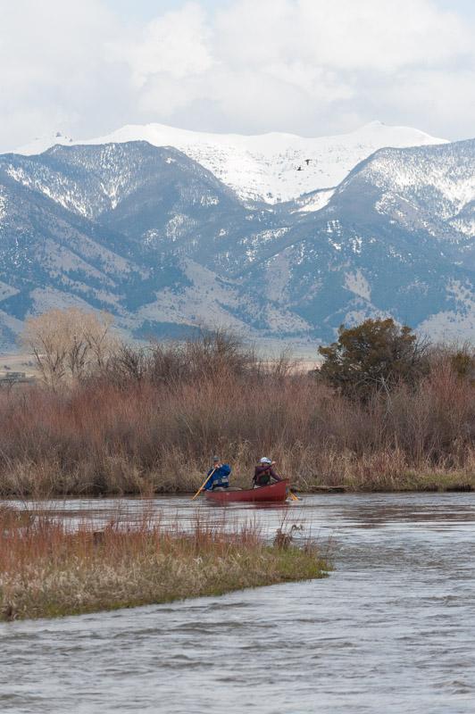
The East Gallatin gathers itself from the Bridger Mountains, the Hyalite Peaks, Bear Canyon. Rocky Creek, Bear Creek, Cottonwood Creek, Bozeman Creek, Bridger Creek and a handful of other mountain streams join together to create the flow that meanders for 35 or 40 miles across the Gallatin Valley until it joins the West Gallatin and proceeds down to the headwaters of the Missouri. The precise headwaters are vague. Some maps put it at the confluence with Bridger Creek, a few turns down. Others have it at the confluence of Rocky and Bear Creeks, a few bends up.
It is a storied piece of water, in its way. William Clark made his way up the East Gallatin riding horses on his way to the Yellowstone River and his rendezvous with Lewis near the confluence of the Yellowstone and Missouri the summer of 1806. Clark remarked on the plentiful beaver, which made travel boggy and difficult, and noted the ferocity of mosquito life. The Indian peoples of the region called the Gallatin Valley ‘Fat Valley’ for its bounty of game and edible plants. I’ve heard that indigenous people set aside the valley as a safe zone of peace and plenty.
In the time since the Shoshoni and Blackfeet and Crow, since Lewis and Clark and the fur-trade era the region is so famous for, the East Gallatin has been, from all evidence, a garbage dump. That became clear within the first bend. We started picking up the detritus of generations of people who operated on the out-of-sight-out-of-mind theory of waste disposal. Our canoe hulls filled up with rubber boots, old tires, Styrofoam coolers, lawn furniture, soccer balls, fishing bobbers, scraps of metal, hoses. Never mind the stuff we couldn’t fit into our hulls – stoves and refrigerators, old cars imbedded in the banks as riprap, tractor tires. Our canoes transformed into garbage scows, precarious with muddy trash.
It was appalling. These creeks and rivers make the valley the lush and verdant place it is. Without them Bozeman, the Gallatin Valley, local agriculture, towns and settlements, none of it would be tenable. The bends full of beaver William Clark complained about are what make the soil fertile, the vegetation thick, the habitat rich. And here’s how we expressed our appreciation, by dumping our cars, our kitchen sinks, our junk over the banks, not to mention trapping the beaver to near extinction.
Towns everywhere have located along streams like this. Without the water flowing past, these communities couldn’t function. Creeks and rivers like the East Gallatin bequeath the water that runs out of taps, flushes away wastes, waters lawns, irrigates crops, lubricates industry. They provide the everyday lifeblood that makes settlement possible. And yet, time and again, these life-giving flows are polluted, littered, exhausted, ignored and taken for granted. They deserve reverence, gratitude, respect, and yet, they are universally abused.
To my surprise, a few bends in, the small river began asserting its magic. Sullied, yes, but also fun, heads up, full of life. Warblers flashing in the willows, sandhill cranes calling from the banks, white-tail deer in the brush, red-tailed hawks screaming overhead. At stops to gather more garbage, raccoon prints stippled the mud. Every bend held a surprise. More than once a log jam or beaver dam or wall of vegetation blocked the way, forcing us to drag around or over or through. The current ran headlong into corners, through overhanging brush. In spite of the accumulating heap of garbage weighing down the boats, despite the insulted river, we were giggling with the goofy challenge like kids on a joyride.
The next week, that spring, I went back. I kept gathering garbage, but more than that, I started using the East Gallatin like a gym workout. A gym work out and, in a way, my church; the place I went to for solace. I could bike the shuttle and be self-sufficient. Again and again, that spring, and the next, and the one after that, I kept returning, sometimes several times a week, until I knew that little flow on the outskirts of town as well as the dog walk I took every morning. And it was mine alone. I never saw anyone else on the water.
Marypat hasn’t paddled the East Gallatin nearly as often as I have. She has her own, different, adventurous compulsions. But she knows it well, and appreciates the elements of surprise that are inevitable, especially on the first run of spring. Some surprises are gifts, like the log jam I expect two bends down that has been swept away in the year since I paddled it. Other surprises, not so pleasant. Around a corner with little chance to react we come upon a log across the channel. Marypat draws the bow into shore, I swing the stern around and paddle hard upstream, into the bank, where MP grabs a fistful of willow and hangs on. I grip a branch while she climbs out and scouts a way around through the thick vegetation. There are old patches of snow still in the dry cattails. We shove the canoe through the brush, over a log or two, and back to the river below the obstruction.
The river is dynamic. I know this conceptually, but also viscerally, by virtue of all the years I’ve watched it change, and by reacting to those changes. A log jam of thick-hulled cottonwood trees seems absolutely permanent, lasts for years, gathers bulk, and then, one spring, is miraculously gone. But a new one appears two bends down. Beavers come and go with their matrix of dams. Oxbow bends become more and more pronounced, until, one spring, a new channel cuts the ‘bow’ and straightens the channel. A river bend erodes under a barbed wire fence that drapes dangerously over the channel. I admit to carrying fencing pliers and cutting a few strands of wire. Every year and every water level has its mix of beneficence and hazard.
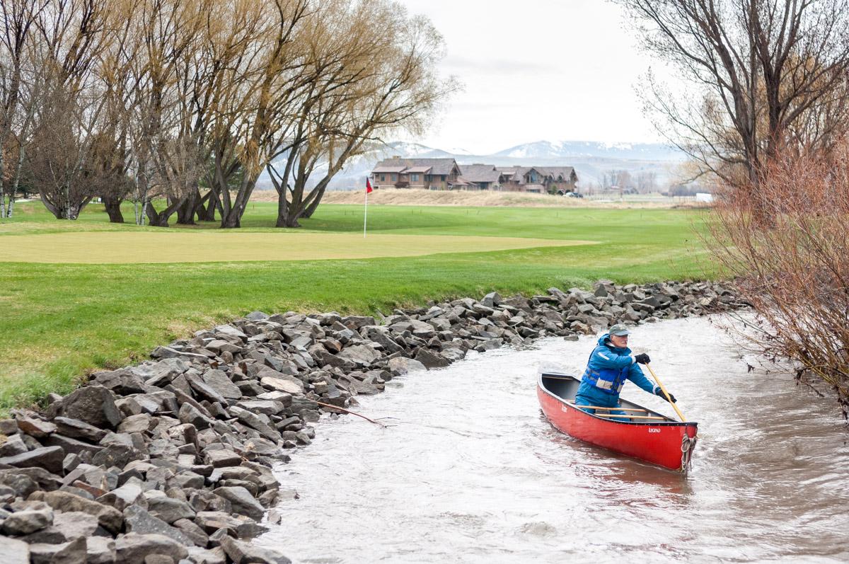
This year with Marypat is no exception. We sweep around corners, hugging the inside of the bends, craning for the next surprise. Passages are hemmed in by overhanging willows. We duck under branches that brush our backs. A homeless camp slides past, old tarps, a flannel sleeping bag draped in the underbrush, a cable spool for a table. A Canada goose flushes from its nest. Rambler station wagons jut out of river banks. We whip around a corner next to a golf course fairway and another log blocks the channel. Again, Marypat plants a strong draw, the canoe swings into shore, we both scramble for a hold before the canoe is swept into the tree.
“Hey, is that Al and Marypat?” I hear from across the river. “What the hell are you guys doing?”
“Oh, hey Bob. Hi Susie,” I recognize friends from town out playing a round of golf. “Just out for a little float.”
“Of course you are,” Susie laughs, watching us heave our boat across the log.
A large measure of what makes this run sweet is the through-the-looking-glass feel of it. It goes past subdivision back yards, by several golf courses, within view of the old town dump, under roads. It is delicious to sneak up on someone lining up a putt, or out on their patio, or tending horses in a corral and surprise them. “Is this the way to St. Louis?” is my stock greeting. This is not one of those popular floats full of yellow inner tubes towing six-packs of beer. Good thing, because if you don’t know what you’re doing with a paddle, you’ll get hurt.
Thomas Lee photo
By the time we go under the side road that marks the halfway point, we’ve had to hop out and pull around something four times. I have never had a clean run down this section, but it is particularly gnarly this year.
“I’m glad I’m not solo,” I say to my partner. “Thanks for coming.”
For years I stuck to this upper piece of the river, over and over again. I’m nothing if not a damn creature of habit. Then, one May, my friend Scott said that he had Mondays off. “What if we did it all, section by section, every Monday in May?” he asked. Why didn’t I think of that? I chided myself.
We did just as Scott suggested. The river is sectioned off by bridge crossings at convenient intervals so that we could bump down the watercourse a couple hours at a time, once a week. I introduced him to my well-worn section the first Monday. Then, week by week, we entered the unknown, past more golf courses, through housing developments, across agricultural land. The next two sections were as prone to hazard as the first one, pocked with downed trees, low bridges, sudden choices on the fly. We felt our way around bends, navigated log jams, found gaps in beaver dams, avoided fences, had more than a few close calls. Over the course of that month we did it all, down to the confluence with the West Gallatin.
Since then, I’ve been repeating all the sections, finding my favorite bits, becoming as familiar with the lower river as I was with the upper. The winding section with different views on every bend, fed by spring creeks that keep the channel open even in mid-winter. The last piece that remains runnable all summer long and is especially beautiful in the fall, when it feels wrapped in gold. Each section has a reasonable bike shuttle, so I can do them solo.
Emboldened by Scott’s out-of-the-box perspective, I decided one year to do the entire river in one go. The first time I went solo, up at five a.m., coffee mug stuffed down the front of my life jacket, pushing down through the tangled upper half, then stroking on through ag land, with views opening, cranes calling in the fields, herds of deer flashing away. It took me a solid 12 hours of constant paddling and I was hit by a wall of thunderstorm within minutes of pulling the boat out of the water. A year or two later, I did headwaters to confluence again, this time with my son, Sawyer.
Thomas Lee photo
Anymore, it’s enough to complete a top to bottom run every year, bit by bit. I no longer hit the river as often as I used to, but I get it in, starting with the original fraught piece of water on the edge of town, and bumping my way on down, with friends, on my own, in any season. It’s a treat to introduce friends who know how to handle a boat to my favorite sections. “This isn’t the kind of thing you bring your Uncle Frank from Dayton down,” one friend said. “You could get in trouble on this.”
Near the end of this year’s run with Marypat, there is a choice. The river splits and one channel speeds down an ‘S’ curve obscured by willows, where obstacles often hang up. The other leads into an irrigation canal for a golf course, goes through a culvert, and returns to the main channel below the curve. At the right water level, and with the right amount of gumption, it’s possible to slide through the culvert on a fast tongue of river. It is barely wide enough for our canoe. You have to lie down flat, holding the paddles along side, and then pop up quickly to brace against the main current where the culvert spills out. It’s a dicey, amusement-park, thrill. The kids love it. I considered it for years, every time I went by, before I finally tried it.
We choose the diversion, and also elect not to go through the culvert. We have been in and out of the canoe seven times in a run that takes two hours, tops. A couple of spots were more sporting than comfortable. One more thrill seems unnecessary. We drag the canoe past the edge of a close-cropped golf green and slide back into the river.
Where we pull out, several bends farther along at another bridge, people, some of them neighbors, drive past, looking over at us strapping the canoe on the roof rack. No doubt they are wondering what the hell we’re doing, but that’s our secret.
#
Traditions come and go, at least in my life, and paddling traditions are no exception. My yearly start-to-finish run of the East Gallatin will, one spring, not happen, but while it is still going, the power of my 30-plus-year commitment keeps me honest. Without that expectation, I could easily let it slide, or skip a segment or two. I feel some obligation to the task, to the river, to that magic made up of boat and paddler and current.
With my same friend Scott I maintained a series of May “boy’s trips” that emerged out of an off-handed suggestion to paddle the Dirty Devil River in central Utah. We noticed how it ran through some isolated slickrock canyon country when we were driving past one time. Turned out we didn’t do it that year, because the water never came up. Nor did we get to our second choice, the Owyhee River in Oregon, because the water there came up too much. That first May we ended up doing a week on the Little Missouri River through the badlands of North Dakota. Every year after, in May, we took on another river. We ended up with four or five companions, and the tradition lasted five or six years, until, for one reason or another, we didn’t pull it off one year. Good while it lasted.
More recently, I’ve been caught up in another budding series I call Three Rivers. The impulse rose out of a long-standing fantasy I’ve nurtured to spend the better part of May bumping around Montana and running ephemeral rivers in the state, rivers that only have enough water in them to paddle for a month or two every year. I had this cozy image of myself, camping in riverside sites, figuring out my shuttles, and wandering here and there around the state, led by the scent of the next tantalizing bit of spring flow.
At some point I realized that the fantasy was unlikely to materialize anytime soon. As a stopgap, I sent out a whimsical email to a bunch of paddling friends suggesting a Memorial Day outing during which we’d paddle three different rivers, one on each of the long weekend days, and camp out between – sort of a miniaturized version of my month-long dream. I was shocked when most of the people I’d contacted jumped at the idea. Once I realized what I’d unleashed, I established some protocol. First, I would choose the itinerary. Second, there would be no micro-managing endless email chains discussing who would bring hamburger buns. Third, the expectation was that people would show up, be self-contained, take part in whatever portion of the weekend they wanted to, and have fun.
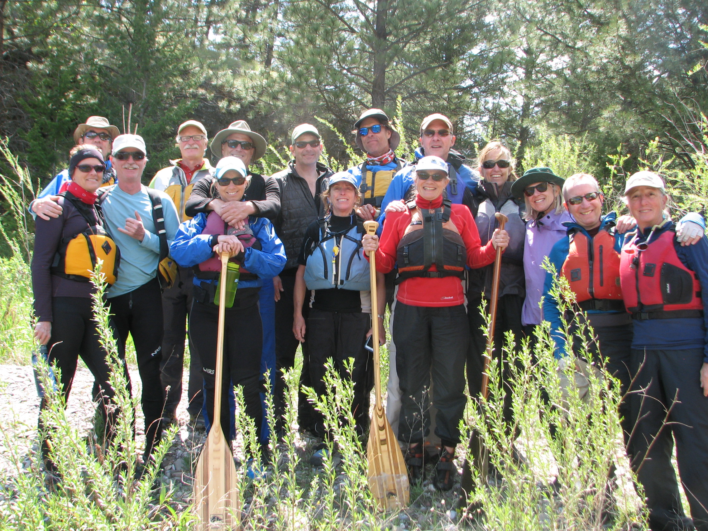
Damned if it didn’t work. The first year I sent out a general itinerary for three bits of water, the camps we would travel to between rivers, and set a time for everyone to show up Saturday morning at a wide spot on a rural state highway in central Montana next to Belt Creek. Sure enough, at 10 a.m. in a drizzle, a respectable crowd wheeled in, ready for the weekend. The tradition is now six years on. If anything, the event has gathered steam. We’ve had as many as eleven inflatable canoes strung out in parade formation snaking down little creeks and rivers all over Montana. Members show up from as far away as Arizona. We’ve had to limit participation.
Rivers and conditions have run the gamut from gorgeous and sedate to unlikely and hilarious. So far, no one has gotten seriously hurt. There have been hot moments of escape to river banks to avoid downed trees, a few capsizes, some boat punctures due to lethal hawthorn thickets, borderline cases of hypothermia, bridges so low we had to turn our heads sideways as we slid under to save our noses, sudden downpours so pelting that we’ve literally been blinded. Some stretches are nice to have done, but not worth repeating, ever. Others are ones to mark for a return. Some of the best have been the ones we’ve known the least about, or that seem the least likely – places like Silverbow Creek, downstream from the Superfund site in Butte, Montana, or Big Spring Creek, from the gushing headwaters above the town of Lewistown.
Part way down Big Spring Creek, after spending several hours stuttering through the first two miles, miles full of fences, downed trees, low bridges, portages around obstacles, thickets of thorny brush, Marypat turned to me. “This is the kind of thing I would have killed to do when I was a kid!” Luckily, everyone in that group remains a kid.
Three Rivers crew along the lower Dearborn River
What has made the series satisfying is the overall competence of the crew, and the willingness to take what comes in stride. People have, in fact, shown up ready to go, self-contained, more or less on time, with their poop in a group. They take part in the rivers that appeal to them, pass on the ones that don’t. We caravan from spot to spot, take over campgrounds. There is no pressure, but once we get on the water, everyone is all in.
It’s gone on long enough now that finding suitable prospects has become more challenging. The last two years have required some scouting to ferret out the trio of rivers to target. In April I took a road trip to the deep southwestern corner of Montana, and across the divide into Idaho, checking out candidates.
I began with Grasshopper Creek. It had been suggested by my brother-in-law, Andrew, who lives in Dillon. We were on a ski outing with him in mid-winter. I’d been talking about finding good rivers for this year’s outing, and as we drove over this small, snow-bound creek, he said, “What about Grasshopper Creek?”
It had some of the qualities I’d come to seek – off the radar, no route descriptions, quirky, scenic. What about it? When I came back in April I drove to Bannack State Park to have a look. The flow was adequate, if not plentiful. All I could see were the first few bends through the gold-mining ghost town. Then it disappeared toward a low canyon. I talked to a maintenance guy working nearby. “Could be a fun float,” he said. “I’ve been partway down the dirt road along it in a Jeep. There are a couple of canyon sections. Pretty quiet country – ranches and a mine. Never heard of anyone doing it, but who knows?”
I drove around to the take out, a fishing access on the Beaverhead River near the confluence with Grasshopper Creek. Again, not much visible. I could see a bend or two upstream into ranchland, low hills, a distant canyon. Still seemed like enough water to float a boat. We’d have to slog upstream on the Beaverhead to get to the access point, but doable. Problem was, the entire flow between glimpses was a mystery. Edgy. Problematic. Maybe perfect.
I covered a lot of ground that day. I scoped out such mainstream paddling destinations as Big Sheep Creek, the upper reaches of Red Rock Creek, a section of Horse Prairie Creek, along with some of the Lemhi River over in Idaho. All of them thin, boney, crammed with problems. I came home discouraged. But I couldn’t get the seductive glimpses of Grasshopper Creek out of my mind. I really wanted to get a boat on that little mystery.
A month later, shortly after breakfast on Sunday morning of Memorial Day weekend, people gather on the riverbank adjacent to a campground in Bannack State Park. I have been repeatedly amazed that this crew of smart, old-enough-to-know-better folks keeps following me to these unlikely spots. The day before we ran a new section of the Big Hole River. It was a nice warm up. Sunny, pleasant, easy water, no surprises. Today, in contrast, everyone understands that this is the marquee event, the void. Thunderstorms are predicted. The sky is gray, temperatures cool.
Several people have downloaded our route onto their phones. “It’s between 10 and 11 miles as the crow flies,” says one of them. “But this river doesn’t fly like a crow!” He holds up the screen to show a tortured, twisting blue squiggle.
“Okay,” I say, “here’s the orientation talk. I have no idea what the fuck we’re getting into. That’s the whole of it. I’ve seen the top three bends and the bottom two bends. I know where we start and end, but nothing between. Let’s keep each other in sight and take our time.”
It is a moment when a reasonable voice could interject, bring up some doubts, start the whole house of cards shaking. I half expect it, but it doesn’t come. This group of college professors, physician assistants, art teachers, lawyers, photographers, nurses start milling around, topping off inflatable boats, shrugging into life vests, and then we are on the river. The line of blue canoes snakes around the first few bends past the ghost town buildings, under a footbridge. Tourists watch us go past.
Bannack was founded in 1862, when gold was discovered along Grasshopper Creek, and it served as the Montana territorial capitol for two years, before it was relocated to Virginia City, another mining boomtown. At its height, Bannack had some 10,000 residents who supported three hotels, three bakeries, three blacksmiths, two meat markets, a grocery, restaurant, brewery and four saloons. It was a violent town, famous for its vigilante justice and spontaneous, no-trial hangings. In the first year more than a ton of nearly pure gold was pulled out of the area, but the easy pickings quickly dwindled and interest shifted to other strikes elsewhere in Montana, places like Alder Gulch and Last Chance Gulch. Still, Bannack boasted a few permanent residents into the mid-twentieth century. In 1954, the town’s last resident, C. W. Stallings, sold the whole enchilada for $1,000 to citizen groups interested in maintaining the historic character of the area.
Not long after the weathered buildings and wooden boardwalks maintained by the state park are out of sight, the first canyon swallows us. Valley sides steepen, the creek picks up speed, runs through rock-choked channels. A boat hangs up on a rock and in short order three or four more boats pile in. People hop out, horse the rubbery craft past overhanging brush, through minefields of boulders. Subdued chaos ensues. Several of the younger members are doubled over laughing at the sight of gimpy elders hot-footing around in knee-deep water. This goes on for a mile or two. Eventually we figure out the spacing better, get more proficient at navigating the obstacles, but it remains a circus.
Then the valley flattens out. The creek loops in tortured bends back and forth. On the outside of every corner prickery brush hangs over the flow. Boats drag past or through the branches, depending on teamwork. There is no time to lay back and enjoy the float. I can’t even find time to clean my glasses. Several hats are lost to overhanging branches. The bends go on and on. A low, funky bridge made out of what looks like flattened car bodies requires a portage around.
Marypat and I find ourselves in the lead, just in time to see a cow moose and calf cross the river, flounder up the steep bank, and crash off into the willows. Out of nowhere, a cowboy on horseback appears, watches us go past, and spurs his horse away. It starts to rain. Everyone pulls on weather gear. It comes down hard and cold for a while, long enough to get tiresome. Then it quits and we decide to pull off and have some lunch in a spot of sun. Those with maps on phones report that we’re maybe a third of the way down. We’re a motley crew, munching sandwiches, taking pees in the sagebrush, drying gear. Someone has a shirt that is ripped to shreds by the vegetation. He looks like a victim of self-flagellation. More hats are reported lost.
Right after lunch we enter the second canyon. Immediately one of the boats gets hung up in some shrubbery on a tight bend, the next boat runs into them and capsizes. We regroup. The canyon, it turns out, is a lovely couple of miles past overhung walls, rockbound corners, largely free of obstacles. Magical and unexpected. But then, immediately following, the stream cants downhill through rock-strewn stretches that call for strenuous maneuvering and evoke even more strenuous conversations between bow and stern paddlers. More hilarity among the younger set. Another portage around a crude ranch bridge and over a fence. Suddenly, a mining operation with a sign requesting that visitors have appointments. No one around. We coast past.
It goes on. Another slow and winding stretch, followed by an absolute hairball section of fast water with several thick cables strung inexplicably over the channel, with logs across the pushy current, with fast tunnels of water through face-slapping willows. An occasional eddy or small gravel bar provides momentary respite where we can gather up and make sure everyone is accounted for. We are more than halfway, but it’s late afternoon and no telling what challenges lie ahead.
People are tired. Clothes are tattered. Hats are in short supply. We continue. The day wanes. Every outcrop of rock worries me – another canyon, a waterfall . . . The creek winds past some pasture. This ten-mile postage stamp of Montana backcountry, with a state park on one end and an interstate highway on the other, where nobody goes, reveals itself in a slow motion scroll. Several times I think about all the similar spots in this state. This isn’t federal land, a park, any kind of designated wilderness, just a patch of country with some ranches, some off the radar enterprises, difficult access, also full of lovely canyons, a thriving population of moose, all of it sitting quietly in the middle of things.
The parade of blue boats bobs around the bends like a gaggle of ducks. Another moose and calf heave out of the river and trot away. Rain showers come and go. We have headlamps, I think. Someone said they brought matches. I measure the sun against the horizon.
Then, unexpectedly, I see a semi-trailer going past on the interstate that I know runs alongside the Beaverhead River. Another couple of bends and the Grasshopper joins the Beaverhead. We turn up against the larger river, paddle hard, then step out of the boats and slosh on foot, towing boats upstream along the bank the final hundred yards to our take-out. Everyone straggles in, beat, disheveled, grinning like fools.
Someone with a phone announces the total distance and time – 22.5 miles in nine and a half hours. In the gloaming, thunderheads going pink with sunset, a bottle of rum gets passed around. The hot, burning liquid goes down like sweet fire. People are pounding each other’s backs, recounting mishaps, showing off bruises. Relief rises from the group like steam.
Three Rivers parade down the upper Sun River